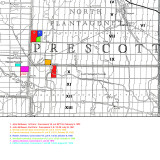
This map indicates the locations of the farms of John McQueen, George Johnson [sic], Francis Johnston, Robert Johnston, Archibald Johnston, James Johnston and Clifford Johnston.
It is thought that George Johnson [sic] was related to Francis Johnston; however, we have been unable to verify this via documentation. Descendants of Francis, Robert, and Archibald have had their Y-DNA tested and all were exact matches for 67 markers. This reinforces one piece of oral family history which indicated that they were brothers.
Both Robert and Archibald were clearing and working Robert's land in 1837. Archibald start working his land to the adjacent south in 1842 according to the Assessment Roll. The deeds were not registered until 1845. They may have been on their land earlier though as this was not uncommon. The land was not taxed until a proper house had been built on the property. Before that it was common place for the owner to live in what was called a "shanty". Shanties were not taxed.
It should be noted that both James and Clifford Johnston owned several other smaller parcels of prime, productive and profitable farmland in the area. These are not shown.