photo sharing and upload picture albums photo forums search pictures popular photos photography help login
Bryan Murahashi | all galleries >> Galleries >> Picture A Day - When I Can 2008 > South San Francisco Bay
previous | next
23-AUG-2008

South San Francisco Bay

view map

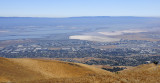
From the top of Mount Allison on the east side of the Santa Clara Valley.

The white spaces in the bay are the salt evaporation ponds for industrial salt.

The hills are much browner on this side of the valley.


other sizes: small medium original auto
share
laine8227-Aug-2008 23:32
A very nice view of the bay, Bryan...very much like the brown we are use to here in Australia
glimpses by lu25-Aug-2008 01:55
Very nice panoramic view!!! One can see a long ways. Great view.
Marcia Colelli25-Aug-2008 00:35
very nice panorama shot V
Guest 24-Aug-2008 20:36
I didn't realize there was open space still left..great view..v
Carol Rollins24-Aug-2008 19:11
Wow, I can see forever! Great shot Bryan, beautifully composed. V
Jackdad24-Aug-2008 18:33
amazing view and it looks very dry there. would love to see a comparison shot in the winter.
January Grey24-Aug-2008 18:15
What a great view from the top! Lovely shot, Bryan. V~
Marco Valk24-Aug-2008 11:19
spectacular view; great shot. v
Guest 24-Aug-2008 10:13
what a view!
and what a clear cloudless sky!
stunning!
laurephotography24-Aug-2008 09:07
Beautiful composition : colors and lines...V
Simon Chandler24-Aug-2008 07:19
So smooth and beautiful. Excellent composition. Thanks for the descriptions. v