Xinjiang is an autonomous region (Xinjiang Uyghur Autonomous Region) of the People's Republic of China and also claimed by the territory of Republic of China.
Older English-language reference works often refer to the area as Chinese Turkestan, Sinkiang, East Turkestan, or Uyghuristan. More specifically, at times, the term East Turkestan only referred to the Xinjiang area south of the Tian Shan mountains, North of the Tian Shan was called Dzungaria (Zungaria).
The general region of Xinjiang has been known by many other names in earlier times including: xiyu) = 'Western Regions', Chinese Tartary, High Tartary, East Chagatay, Mugholistan, Kashgaria, Altishahr ('the six cities' of the Tarim), Little Bokhara and Serindia.
The name "Xinjiang", which literally means "New Frontier" , was given during the Qing Dynasty. In the early part of the Qing Dynasty, the name "Xinjiang" was used to refer to any area of former a Chinese empire that had been previously lost but was regained by the Qing—for example, part of present-day Xinjiang was known as "Western Region xinjiang", present-day Jinchuan County was known as "Jinchuan xinjiang", etc. After 1821, the Qing changed the names of the other regained regions, and "Xinjiang" became the name specifically of present-day Xinjiang.
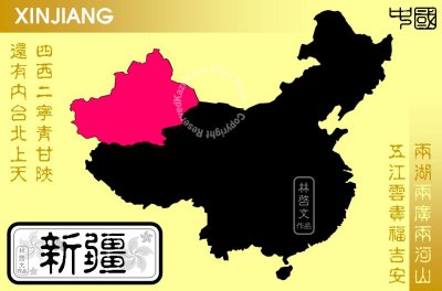
Xinjiang is a large, sparsely populated area, spanning over 1.6 million km˛ (comparable in size to Iran or Western Europe), which takes up about one sixth of the country's territory. Xinjiang borders the Tibet Autonomous Region and India's Leh District to the south and Qinghai and Gansu provinces to the southeast, Mongolia to the east, Russia to the north, and Kazakhstan, Kyrgyzstan, Tajikistan, Afghanistan, Pakistan and India to the west. It administers most of Aksai Chin, a territory formally part of Kashmir's Ladakh region over which India has claimed sovereignty since 1962.
The east-west chain of the Tian Shan Mountains separate Dzungaria in the north from the Tarim Basin in the south. Dzungaria is dry steppe. The Tarim Basin is desert surrounded by oases. In the east is the Turfan Depression. In the west, the Tian Shan split, forming the Ili River valley.