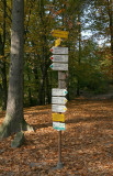
Long walks or rides in the Czech Republic are no problem, at least as far as route-finding goes, since everything is well-marked. This example from near Valdstejn is a bit extreme, of course, but it does show it's hard to get lost. The white signs are walking routes (usually forest paths), and the yellow signs are cycling routes (usually secondary roads). Each path has a color, and many of the cycling routes have numbers. All of the routes are shown on maps (which can take a little work to find, at least before you arrive in the area). Signs like this show up at intersections, but all along the paths, the routes are marked with colored bars (or numbers) every 50-100 m. The marks can be on fenceposts, buildings, trees, rocks- whatever's convenient.