


|
|
|
|
|
|
| |
| 07-JUL-2009 | |
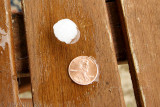
* AT 154 PM EDT... NATIONAL WEATHER SERVICE DOPPLER RADAR INDICATED A SEVERE THUNDERSTORM CAPABLE OF PRODUCING PENNY SIZE HAIL. THIS STORM WAS LOCATED NEAR OSTERHOUT... AND MOVING SOUTHEAST AT 15 MPH.
Well, not quite... but close!
I know this isn't big news to people in the mid-west, but it's the biggest hail I've seen here so far!
| Full EXIF Info | |
| Date/Time | 07-Jul-2009 14:25:18 |
| Make | Canon |
| Model | Canon EOS DIGITAL REBEL XT |
| Flash Used | No |
| Focal Length | 22 mm |
| Exposure Time | 1/100 sec |
| Aperture | f/5 |
| ISO Equivalent | 800 |
| Exposure Bias | |
| White Balance | |
| Metering Mode | (-1) |
| JPEG Quality | |
| Exposure Program | |
| Focus Distance | |
All photos copyright © Bill Ko and must not be reproduced without permission
| comment | |